 |
 |
BLM Durfee Hills
Not
Lands Identified For Disposal
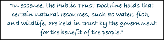
What's at stake for the Public?
BLM's Resource Management Plan (RMP), "To ensure the best balance of uses and resource protections for America’s public lands, the BLM undertakes extensive land use planning through a collaborative approach with local, state and tribal governments, the public, and stakeholder groups. The result is a set of land use plans – called Resource Management Plans – that provide the framework to guide decisions for every action and approved use on the National System of Public Lands." I received a call from a retired BLM employee mentioning that I needed to look into the Judith Valley Phillips Resource Management Plan, the current plan in effect, to see if the Durfees Hills (includes more than just the main BLM lands that are typically associated with the "Durfee Hills", multiple parcels that the Wilks Brothers want that have public access, including road access) were listed as lands identified for disposal - they were not. Below are 3 maps which better explain what is at stake. The first map shows the BLM parcels in organe that the Wilks want. THe other BLM parcels are in yellow. The Durfee Hills are a geographic area, not just F-15. The pulbic has aerial access to F-15 and F-14, but we have road access to F-12 through Middle Bench County Road, shown in the 2nd and 3rd maps, which the Wilks have posted Private Road and No Trespassing signs on, I have been on and researched Middle Bench County Road, driving through the larger BLM parcel, which also has road access on it's southern end by South Fork County Road. Below on the left column is an explanation of the Judith Valley Phillips Resource Management Plan, showing these parcels are not identified for disposal and the right hand column is testimony of Jamie Connell, then Acting Deputy Director, now our Montana State Director for the Bureau of Land Management, Department of the Interior, House Natural Resources Committee, Subcommittee on Public Lands and Environmental Regulations, H.R. 2095, Land Disposal Transparency and Efficiency Act on July 19, 2013, as well as Montana BLM's 2014 press release statements concerning the Durfee Hills.
|
|
|
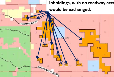
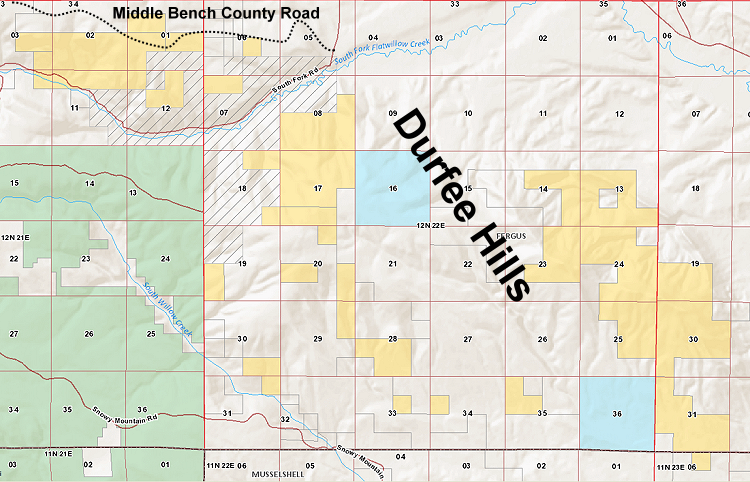
BLM Durfee Hills Lands Under the Judith Resource Area, of which the Durfee Hills are a part of, Appendix C - Land Acquisition and Disposal, you see pages involving the acquisition and disposal criteria, as well as 2 pages of parcels identified for disposal. These parcels are all in 12N21E & 12N22E, with one small connecting 40 acre parcel on the southern end of F-15 being in 11N23E. None of the Wilks proposed exchange parcels are shown on the Judith Resource Area Disposal Map in red, meaning they did not meet the criteria for disposal. Chapter 2 - Resource Management Decision, page 22 states, "Areas not identified for disposal will be managed for longterm public ownership." In fact, Appendix A - Land Acquisition and Disposal, page 2, under criteria for lands acquisition, the Durfee Hills would meet the Wildlife Habitat Management criteria to be acquired as they are home to one of the largest elk populations in Montana, providing important habitat security and breeding/calving areas - "Areas for acquisition will be lands with significant wildlife values as defined below. These areas may be of any size... 3. Big Game. Important habitat such as crucial winter areas in I (Improve) and M (Maintain) allotments with native habitat and associated spring/fall transition areas, kidding/fawning/calving areas, crucial wallow complexes, mineral licks, and security areas." These Durfee Hills Little Snowy Mountain parcels are shown on the Visual Resource Management Classes map as a Class II designation, with Classes I & II being the most valued, acccording to the BLM Manual H-8410-1 - Visual Resource Inventory. Under
Map 3 - Access, you can see that F-12, on Middle Bench County
Road was acknowledged as having public access, while F-15 is shown
to be color coded as BLM land needing new legal public access,
while we had it for the Bald Butte section of F-14 at the time
the map was created. Under Appendix L - Access to BLM Land it
states, which these parcels are a part of under the Little Snowy
Mountains, "Public Demand - Public demand is closely tied
to resource
|
Statement
of Jamie Connell, then Acting Deputy Director, Bureau of Land Management,
Department of the Interior, House Natural Resources Committee, Subcommittee
on Public Lands and Environmental Regulations, H.R. 2095, Land Disposal
Transparency and Efficiency Act
July 19, 2013 "The 1976 Federal Land Policy
and Management Act (FLPMA) provides clear policy direction to the
BLM that public lands should generally be retained in public
ownership. However, section 203 of FLPMA allows the BLM
to identify lands as potentially available for disposal if they
meet one or more of the following criteria: On Sept. 26, 2014, Lewistown BLM published a press release concerning the BLM starting the process to restore access to the Bullwhacker, with contact information, purpose and 3 scoping meetings at the beginning of Dec. It also stated, "A proposed land exchange to restore access was considered, but was determined to be not in the best interest of the American people who have entrusted the BLM to manage their public lands for them. " Enhancing Access to BLM-managed Public Lands by Jamie Connell, State Director - BLM Montana/Dakotas "As the days grow shorter and the weather cools, thoughts turn to fall colors, football, and, of course, hunting! Our agency, the Bureau of Land Management, has hunting covered. Under our multiple-use mandate, the BLM manages 8.3 million acres in the states of Montana, North Dakota, and South Dakota, much of which is open to hunting and shooting activities. Public lands are unique to our country and something we should all be proud of as Americans. Enhancing public access to public lands is one of my Top 10 priorities as State Director and, to further that, I established an internal Access Board in 2011. Its charter is to pursue opportunities to increase public access to public lands. Montana's checkerboard pattern of ownership can leave travelers unsure of land ownership, and there are BLM parcels that have no available public access. In addition, there are several Montana/Dakotas examples where access to historically available public lands has been blocked. One such example is the Bullwhacker road within the Upper Missouri River Breaks National Monument. A change in ownership, following a legal determination that a portion of the Bullwhacker road was privately owned, resulted in a loss of road access to more than 50,000 acres of public lands. The Mabee Road north of Roy is another such example that resulted in the loss of public access to over 10,000 acres of BLM-managed lands. While we respect private land rights we also recognize the public interest in regaining the loss of access and establishing new public access where opportunities arise. We pursue new access routes by acquiring easements, through land exchanges where possible, or new road construction across BLM-managed land where there are no other options available. In this process, there’s always some “give and take” so I ask you to be flexible. Know that any land exchange the BLM enters into must have a resounding benefit for the public, and that it will be an open and transparent process in which the public can participate." |
Site designed and maintained by Kathryn QannaYahu
![]()