| Putting the "Public" Back In "Public Trust" Wilks
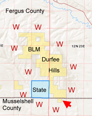
illegal fencing comments needed This quick newsletter is focusing on one issue this time, that being the wildlife obstructing illegal fence the Wilks have erected around our BLM public lands known as the Durfee Hills, in Fergus County, needing your Public emails to correct this situation. The BLM Durfee Hills sits in the middle of a ring of parcels owned by the Wilks.
Here is the Timeline of the events involving the Wilks Ranch fencing issue.
Here are the various aspects of those
laws and regulations, which I have stored full documents on a
Fencing
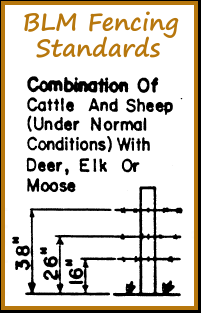
Page of the EMWH website. The BLM Handbook states 3-4 wire fence
involving deer, elk, moose or antelope with a top height of 38",
40 is acceptable if necessary with cattle. The bottom wire needs
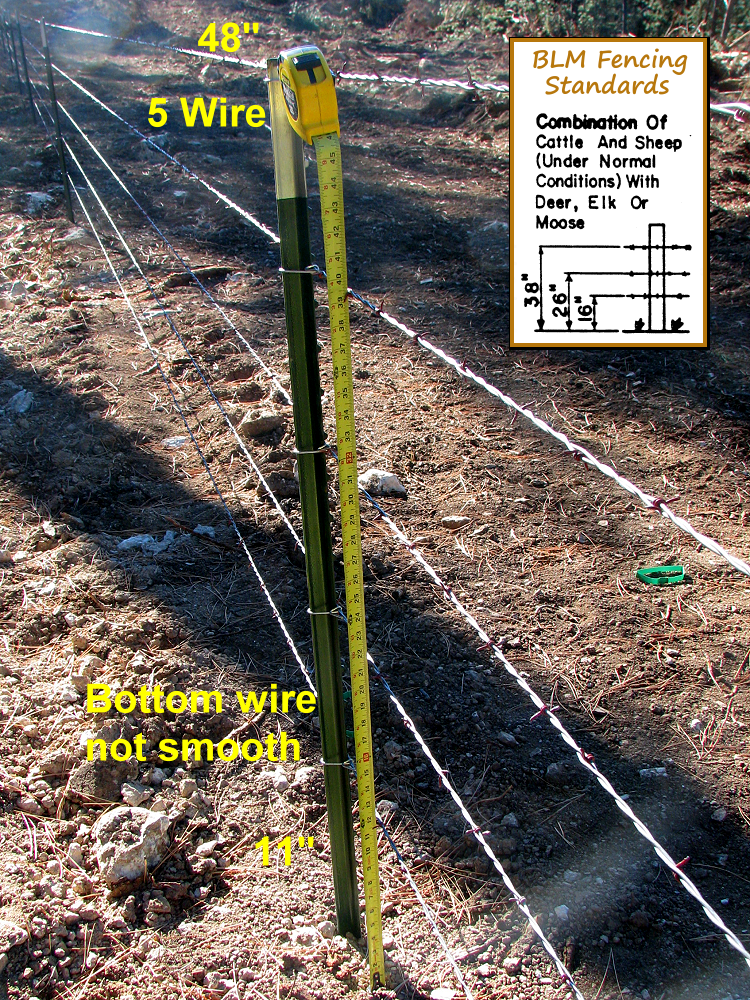
to be smooth and 16" from the bottom as shown below. Below
is a pic of the Wilks fence which has been reported as higher
than 48" and the bottom wire in this one is about 6"
off the ground - 5 wire.
Wanting the copies of the surveys, I made a call to the Fergus County Fergus County Clerk & Recorder, to see about electronic copies of the BLM land surveys. They could not locate the parcels in question without a Certificate of Survey (COS) number. I had Geocodes and Legal Descriptions from the Montana Cadastral program, which did not list any Certificate of Survey numbers. The clerk referred me to the Fergus County Assessors office who could take my Geocodes and give me the COS for each parcel. Problem was, there has never been any professional surveys on record for these BLM lands in order to have a Certificate of Survey number, not one. I checked all the surrounding Wilks parcels with the Cadastral and none of those show any COS either. I called the Assessors office back and ran a number of these parcels through, providing the Geocodes and no Certificate of Survey numbers for the Wilks parcels either, not even the smaller one that was part of a large block of BLM land. One of my questions: How can fences be erected without a survey? Also, "After BLM staff conducted a flyover and ground visits using a survey-grade GPS, no encroachment was found," if there has not been a professional survey? After speaking with professional surveyors, confirming with FWP that they did not give approval to the Wilks for the fencing as rumored (which I have stated they did not have jurisdiction to do), and speaking with BLM who confirmed there is no professional survey, I concluded the necessity of requesting the BLM to conduct a professional survey of our public lands to protect our Public Trust from special interests. At issue here is a wildlife obstructing non-compliant fence, which may be partly on private land and partly erected on public (due to WAAS enabled GPS readings), ground disruption and damage to Public Lands, unlawfully enclosing our Public Lands (UIA), possible posting of no trespass signs on Public Lands (should the professional survey corroborate the GPS readings) and the possible intent to privatize our Public Wildlife. The reason I bring this last subject up, is if the Wilks were simply erecting a fence to mark their boundaries for any of the Public that flew into the Durfee Hills, why go to the labor and cost to erect a 5 wire wildlife obstructing fence? A 3 or 4 wire would have sufficed for marking boundaries. Below is part of a letter which I sent
to the Bureau of Land Management State Director Jamie Connell
requesting the BLM conduct a professional survey and investigate
the Wilks fence around the Durfee Hills. Please use any of this
information and the email link below to send a letter, standing
up for our Public Lands. Bureau of Land Management State Director Jamie Connell, I am writing to request the Bureau of Land Management, a trustee/trust manager of our public lands, to conduct a professional survey of the Durfee Hills in Fergus County, Montana, which does not have a current professional survey, per the Fergus County Assessors office – to define the legal boundary, to check for ground disruption and that private fencing does not encroach on our public lands. I would also like to request that you
investigate the Wilks 5 wire fencing being erected to determine
it's compliance with the Unlawful Inclosures of Public Lands Act,
which is cited in your BLM Fencing Standards Manual H-1741-1,
“Fences Along Public-Private and Public-State Land Boundaries,
The responsibility to install fencing along the boundary between
Federal public lands and lands owned by non-Federal entities (i.e.,
State, local, private) generally rests with the non-Federal landowners...The
Unlawful Inclosures Act of 1885 (UIA), as amended, is applicable
to fencing constructed along or adjacent to public lands. This
law states, in part, that 'No person, by force, threats, intimidation,
or by any fencing or enclosing, or other unlawful means...shall
prevent or obstruct free passage or transit over or through the
public lands...' The courts have ruled that the UIA guarantees
access to public lands for all lawful purposes and that wildlife
access to and use of Federal lands is a legitimate use. ” 08-2143-14-1-03-01-0000 (S14, T12 N, R22 E, S2NE4, SE4NW4, E2SE4) 08-2143-13-1-03-01-0000 (S13, T12 N, R22 E, SW4NE4, S2NW4, S2S2, NW4SW4, NW4SE4) 08-2143-23-1-01-01-0000 (S23, T12 N, R22 E, NE4, N2SE4, NE4SW4) 08-2143-24-1-02-01-0000 (S24, T12 N, R22 E, G LTS 2,3,4, W2E2, NW4, SE4SW4) 08-2144-19-3-01-01-0000 (S19, T12 N, R23 E, G LTS 3 AND 4, E2SW4, W2SE4) 08-2143-25-1-01-01-0000 (S25, T12 N, R22 E, G LTS 1,2,3, W2NE4, NW4SE4, NE4NW4) 08-2144-30-1-02-01-0000 (S30, T12 N, R23 E, G LTS 1,2,3,4, E2NW4, NE4SW4, N2SE4, S2NE4, NW4NE4) 08-2144-31-2-02-01-0000 (S31, T12 N, R23 E, G LTS 1,2,3, SE4NW4, E2SW4, SE4) 23-2034-06-1-01-02-0000 (S06, T11 N, R23 E, GOVT LT 2)
|
08/10/2014 Enhancing
www.EMWH.org
For More EMWH
|